The geology and paleontology of the Caldecott Tunnel's Fourth Bore
A UCMP/Caltrans collaboration
by David K. Smith
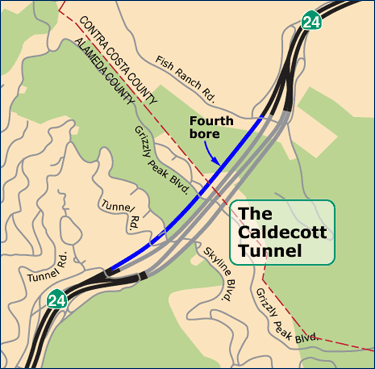
The population of the East Bay has grown significantly in the 49 years since the Caldecott Tunnel's third bore was completed (1964) and for the past several years the Caldecott has been a major traffic bottleneck for State Route 24, particularly during commute hours and weekends. Being the primary connector between Alameda and Contra Costa counties, support for the addition of a fourth bore continued to grow until— In August of 2007, the California Department of Transportation (Caltrans) signed off on a project to construct a fourth bore for the Caldecott Tunnel. Funding was awarded in 2009, ground was broken on the project in January 2010, and in less than four years, on November 16, 2013, traffic was flowing through the new tunnel.
This web feature will explore the geology and paleontology of the Fourth Bore.
![]() I. The geologic and tectonic history of the East Bay Hills
I. The geologic and tectonic history of the East Bay Hills
![]() II. The geology … and dealing with it
II. The geology … and dealing with it
The rocks encountered during tunnel excavation, the potential difficulties they posed, and how the excavation crews dealt with them.
![]() III. The fossils associated with the Caldecott Tunnel
III. The fossils associated with the Caldecott Tunnel
What fossils have been found and what they can tell us about life in what is now the East Bay during the Middle and Late Miocene.
I. Geologic and tectonic history of the East Bay Hills
Although the story of the East Bay's geology dates back many millions of years, the area didn't begin to take on the look it has today until the Middle Miocene, about 15 million years ago. That's when the San Andreas Fault System arrived on the scene. Since the fault system has been such a major player in the modern history (geologically speaking) of the Bay Area, we should say something about its origins.
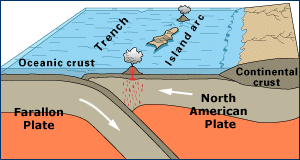
The Farallon Plate subducting beneath the North American Plate. Adapted from a graphic on the USGS Understanding Plate Motions web page.
To explain the origin of the San Andreas Fault System, we have to go back about 145 million years, to the beginning of the Cretaceous period, when the Farallon Plate, moving eastward from a spreading center in the Pacific, collides with and begins to subduct beneath the North American Plate. Volcanic island arcs begin to form offshore. By about 30-25 million years ago, during the Oligocene, the Farallon Plate is almost entirely subducted and the Pacific Plate is making first contact with the North American Plate at what is now the southern California coast. Subduction is replaced by strike-slip movement along this boundary — the new San Andreas Fault System — and this transition slowly moves northward. Prior to the system's arrival in the Bay Area, clays, silts, and sands are accumulating at the outer edge of the continental shelf (the Sobrante Formation) with the coast being somewhere in the neighborhood of Livermore.
The continental shelf retreats eastward and what is now the East Bay becomes an ocean basin between 1500 and 1600 meters deep. Between 17 and 14 million years ago, clays, sands, the frustules (hard, porous cell walls) of diatoms, and the tests of foraminifers accumulate on the sea floor (the Claremont Formation).
As the San Andreas Fault System draws nearer, the sea floor begins to rise. By 12 million years ago, the sea has receded, the sea floor is exposed, and terrestrial sediments begin to accumulate. A high area forms in the vicinity of the current San Francisco Bay and silt, sand, gravel, and cobbles are shed eastward towards a shallow marine embayment east of what is now Moraga. A thick layer of this material accumulates as an alluvial fan (the Orinda Formation) over a two-million-year period as the land continues to rise. By 10 million years ago, the marine embayment starts to recede.
With the change from subduction to a strike-slip fault boundary, a "slab window" forms (see graphic below left), allowing upwelling mantle to fill the space once occupied by the subducting Farallon slab. Lava erupts from what is now Round Top in the Sibley Volcanic Regional Preserve about 9.5 million years ago. This heralds in a period of volcanism lasting almost two million years; a series of lava flows (the Moraga Formation or Moraga Volcanics) buries the previously deposited sediments. The high land to the west continues to shed sediments eastward; periodically, sediments cover the lava flows.
The volcanism ceases about 8.4 million years ago and sediments begin to accumulate in a lake that extends northwest from what is now the region of Moraga. After another couple million years, deposition in the area is replaced by a long period of erosion.
Then, about 3.5 million years ago, there is a small change in the angle at which the Pacific and North American plates collide. Instead of sliding by "smoothly," a compressional component is introduced. At 2.5 million years ago, the rocks laid down over the past several million years are faulted and folded; the East Bay Hills begin their rise. A series of thrust faults cause the emergence of Mt. Diablo.
Today, both the relatively young (geologically speaking) East Bay Hills and Mt. Diablo continue to rise at the respectable rate of one to two millimeters a year; this translates to ten to twenty meters after a mere 10,000 years (assuming no change in the rate of erosion). Earthquakes are a constant reminder that the Pacific Plate continues to move northwest relative to the North American Plate (see graphic below right). Generally, lateral movement along the two plates — averaging just over 4 cm per year — is either a slow creep or a sudden slip. If it's a big slip, resulting in the release of many years of stored energy, then watch out!
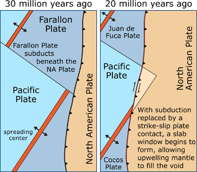
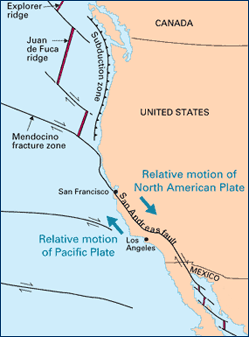
Left: Formation of a slab window along the west coast of North America. Adapted from a graphic on the USGS What Is a Tectonic Plate? web page. Right: Current plate motion along the west coast of the United States. Adapted from a graphic on the USGS Understanding Plate Motions web page.
Next page >>