Home | Session 5 | Bay Area Geography Pg 1, 2
Bay Area Geography and Geology
Presented
by Richard Sedlock
San Jose State University and BAESI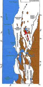
- Key Bay Area geographic features
Use the corresponding numbers (below) to label the following features on Figure 1 (right, click to zoom in).
- Santa Clara Valley & San Francisco Bay
- Livermore Valley
- Mt. Diablo
- Suisun Bay
- San Pablo Bay
- Monterey Bay
- Point Reyes
- Farallon Islands
- Santa Cruz Mountains
- East Bay Hills
- Diablo Range
- How These Geographic Features Formed
First, some basic principles:
Sediments are derived from the weathering of older rocks.
After sediment is weathered from older rocks, it undergoes erosion: it is first transported (chiefly by running water in the form of streams) to a basin, or low-lying area, and then it is deposited in layers.
Sedimentary rocks form when sediments lithify, or turn into rock. Common sedimentary rocks: shale (lithified mud), sandstone (lithified sand), and conglomerate (lithified pebbles).
Weathering and erosion are accelerated wherever uplift of the land surface occurs. Some rocks have been uplifted several miles, e.g., marine strata on Mt. Everest.
At the latitude of the Bay Area, the modern transform formed about 12 million years ago (Ma). The transition caused all sorts of geologic changes that are reflected in topographic changes.
updated March 4, 2002
UCMP Home | What's new | About UCMP | History of Life | Collections | Subway
![]()