Bay Area Geography and Geology, Figure 1
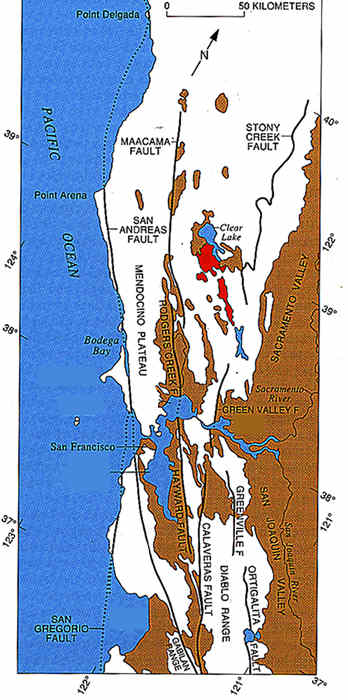 Geologic
sketch map of the northern Coast Ranges, central California, showing faults
with Quaternary activity and basin deposits in northern section of the
San Andreas fault system. Fault patterns are generalized, and only major
faults are shown. Several Quaternary basins are fault bounded and aligned
parallel to strike-slip faults, a relation most apparent along the Hayward—Rodgers
Creek—Maacama fault trend.
Geologic
sketch map of the northern Coast Ranges, central California, showing faults
with Quaternary activity and basin deposits in northern section of the
San Andreas fault system. Fault patterns are generalized, and only major
faults are shown. Several Quaternary basins are fault bounded and aligned
parallel to strike-slip faults, a relation most apparent along the Hayward—Rodgers
Creek—Maacama fault trend.
| Alluvial and estuarine deposits (Quaternary)--chiefly basin fill; may also include some Pliocene deposits. | |
| Clear Lake Volcanics (Quaternary and Tertiary)--flows, tuffs, and breccias of dacite and rhyolite and less abundant basalt. Age is late Pliocene to Holocene. | |
| Bedrock (Tertiary and older)--varied rock types | |
| ____ _ _ _ |
Fault exhibiting evidence of Quaternary displacement--dotted where concealed by water. |
Source: USGS Professional Paper 1515, p.85.
updated April 3, 2002
UCMP Home | What's new | About UCMP | History of Life | Collections | Subway
![]()